 virtual
regatta planning tool
virtual
regatta planning tool |
VRTool
is an application designed to help you plan virtual regatta legs.
This version was written with the Volvo
Ocean Race Game in mind. It is freeware. Support is
available in this page, in the game forum "free routing software
(VRTool)" and in the game group "VRTool"
(join to receive update notifications and news). Please do not
ask questions via e-mail. Use the game forum so others can share
the information.
VRTool screenshot
 Features
- Track planner - Draw your planned track and calculate times
in critical points. Tune for wind forecasts as you go. Try different
strategies to minimize track times and take advantage of wind
waves.
- Great circle and rhumb lines calculator for long passages.
- Wind grid visualization options showing arrows, barbs, wind
speed, boat polars, and wind direction. Wind speed color
gradient. Wind rectangle boundaries. Optional filters to hide
winds too weak or too strong.
- Track animation - Review legas at high speed.
- Import boat routes (complete, but no time information)
- Import boat track points (one by one, as you go)
- Export data to other softwares. All data files in text format.
- Freeware - But use at your own risk. No support via e-mail.
What it does NOT
- VRTool will not perform any control action (like change course,
sail etc).
- VRTool is only for Windows machines (XP, 2000,
2003, Vista).
Installing
1) Download the installer file using the link below and save to
your Windows desktop.
2) After the complete download, run the file. This
will install the software in your system.
3) Run the program using the [Start]
> Applications > VRTool menu or use the desktop
icon.
|
Version changes
version 0.95 - 05/feb/09:
- Proxy support: You can now use either
http proxy or socks (v4) proxy. Click >View
>Proxy settings
- Track Animation improved. Load sample
desktop Leg4-Animation.nav and click >View>Track
animation and experience leg 4 from start to end.
Use the VCR controls to animate tracks. Close animation
panel to return to online mode.
- Update tracks for your boat and friends.
Auto boat update option.
- Improved default polar data, with
sail recommendation. Note: When installing the
update, make sure you overwrite file polaresvoc.csv
with the new one.
- Use the Ctrl key to drag the chart
with any tool.
- Improved Boat Attitude indicator now
shows data for your boat, friends, ruler tool and track
tool.
- Keep an eye on "friends" boats.
Course, sail or wind angle changes can be logged and reviewed.
File Leg5-ChinaRio.nav has some routes:
great circle and rhumb lines. You will note that the shortest
path is further south than you would expect from looking
the plane mercator projection.
version 0.92 - 21/jan/09:
- Corrections: problem with MyPolar lines
(not showing). Corrected wind direction by 180 deg (i.e.
number shown is wind blowing-to direction).
- In addition to the zoom tool, you can
now use the mouse wheel to zoom in and out.
- Option config for Vendée
(with polars provided by user toxinho). Experimental
and not tested. Just dont mix the two together in your
desktops. Each regatta has its own set of default polars
and mypolars.
- Updated sample desktop vrtool.nav (with
Singapore-Qingdao route by user Xiphias).
version 0.90 - 15/jan/09:
- Added a leg timer. Set the regatta start
date/time to activate (in the Boat attitude panel, click
the settings button).
- Added another polar chart database (MyPolars
- see below)
- I had to change some keyboard shortcuts,
because of key conflicts (sorry fellows):
- Use [Ctrl] [W] or [F2]
(instead of [W]) to download wind forecasts.
- Use [Ctrl] [1] to [Ctrl]
[7] to select wind forecasts (instead of [1]
to [7]
|
Updating
If you already have vrtool installed and want to update, download,
run the installer program and install in the same directory (normaly
\program
files\vrtool\ ). Overwrite data files (unless
you edited them).
Using VRTool
Run the VRTool and load the sample desktop (use menu option
File > Open Desktop).
Select sample desktop file vrtool.nav.
This will open the earth chart, including routes, tracks, marks.
You can add your own routes, tracks and marks to the desktop. Remember
to Save As using a different name when you finish the session.
In the tool bar you find the following tools:
- zoom - Click left mouse button to zoom in and right
to zoom out.
- hand - Left click and drag the map.
- ruler - Use it to measure distance and course (if the
wind grid is loaded it will calculate boat speed, track time and
recommended sail, using the polars)
- route tool - Use it to draw multipoint routes. Right
click to finish and give a name.
- track tool
 -
Use it to draw tracks (points with time). If the wind grid is
loaded for the whole track, it will calculate point date/times.
When you cross a 12h intervals, wind forecasts change automatically. -
Use it to draw tracks (points with time). If the wind grid is
loaded for the whole track, it will calculate point date/times.
When you cross a 12h intervals, wind forecasts change automatically.
- mark tool - Use to add marks to de desktop. Choose a
name and icon for your mark (buoys, anchors etc)
- pointer - Use to point things in the desktop. It will
show the associated texts (mark name, track point text, wind speed
etc)
Open the properties frame clicking  .
This will show tabbed pages with the route/track editor; wind options
and Boats. .
This will show tabbed pages with the route/track editor; wind options
and Boats.
Position the mouse cursor over the area of interest and press the
[F2] key (or [Ctrl] [W]) . This will download the
wind forecast for that area. Repeat the procedure as needed
to populate the field.
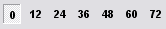 Use buttons [Ctrl] [1] to [Ctrl][7].. or buttons in the toolbar
to display successive wind forecast periods.
Use buttons [Ctrl] [1] to [Ctrl][7].. or buttons in the toolbar
to display successive wind forecast periods.
 Use the leg calculator for great circle and rhumb line calculations
(long distances)).
Use the leg calculator for great circle and rhumb line calculations
(long distances)).
Add these routes to your desktop.
Destination
Set your leg destination. This will enable the VMC (velocity made
good to course) and distance calculation.
To set destination, go to the Boat Attitude panel and click
the [settings button] in the top left of the panel. Edit
latitude and longitude of destination point. VMC, course and distance
to destination calculations use great circle formulas. So don't
try to set your destination from China to the Horn directly. This
will set your course to the south over Australia, Antartida. So
use intermediary destinations for the Pacific passage.
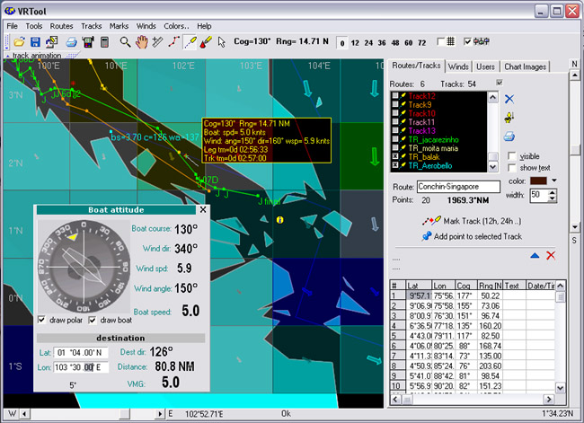
Track planning - Click the draw track tool button .
Click the first point of the track you are planning. As move the
mouse, track data can be viewed in the floating cursor and in the
boat attitude indicator. Left click the mouse to add a point to
the current track. As you draw the track, point times are calculated
based on polar charts and wind data for each point in the track.
Right-Click to finish a track. Choose a name for the track.
Change color, width and other properties.
Use the button [Mark track 12h 24h..] to convert a given
route or track to a new track with extra points added. The extra
points are:
- Crossing wind rectangle boundaries.
- Crossing a wind forecast change time (12h, 24h, 36h etc)
These are the points where you may have to change boat course or
sail, for best performance.
Note: The procedure produces a new track over the original. Delete
or hide tracks using the listbox as needed.
Track properties can be viewed and changed in the routes/tracks
Tab.
Real tracks and Planned tracks
It is important to keep your real track, adding track points one
by one, as you go. You also might want to keep an eye on a few "friends",
keeping tracks for them too. The program you do that for you (see
"Boats" item below).
Planned tracks are drawn with the mouse, always starting in the
last 12h boundary. This will keep the sync between track
progress and wind changes. Go slow as you cross a 12h boundary and
plot a point right after that, so you get a peek of the next wind
arrow before continuing. After the complete track drawing, right
click to finish. Them click [Mark track 12h 244..].
Polar lines
Polar lines allow the calculation of boat speed given boat course,
wind speed and wind angle. Polar lines are used to figure the boat
speed at points along your track and integrate boat movements.
|
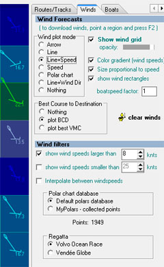
winds tab
|
Default polars and MyPolars
The program can use two polar chart databases.
1- The default database comes with the program
installation (file polaresvoc.csv
in the program directory). The default polars file was improved
in version 0.95 and is now pretty close.
2- A more exact polars database can be gathered from
actual game data during the leg. Its called MyPolars.
This table is build with data from boats and friends, as they
go. The database starts empty. Every time you query boat data
(see Boats topic below) you can add points to MyPolars
database. MyPolars is in file MyPolars.csv.
Vendée option uses different files.
There is no editor for the polar lines in the program. However
the files are text and simple enough to be edited using notepad
or Excel. Restart the program to reload a changed polars file.
|
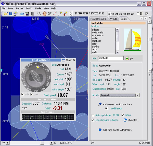
Boats tab
In the Boats tab (former Users tab) you can query the game data
for a given boat and friends. Specify the boat name and click [get].
This will download boat game data. After the download, you may:
- [Add point to boat track] - This will add a point to
a track named TR_boatname (the track is created if needed). Use
this option to create tracks for your boat and friends as you
go. If option checked, friends tracks will also be updated.
The point text will record data about the boat at that point (wind
speed, wind angle, boat speed, course and classification).
- Auto update: this will trigger the update of data for selected
boat and friends, each 10 minutes.
- Log changes - logs course, sail and windangle changes in your
friends boats. Click show log to review changes.
- [add wind points to MyPolars] - Add points from boats
and friends to MyPolars database (current sailing conditions of
these boats).
- [Import route] - This will add the full boat route for
the current leg (without time data).
Keep the list of boats in the memo field and click to copy boat
name to the query field.
Feedback
Contact the webmaster.
You can also check the VRTool forum for program FAQ. Join game group
VRTool to receive update notifications and news.
good winds

sponsor link
|